The Upper Arlington architecture drive: a 12-mile loop, stop by stop
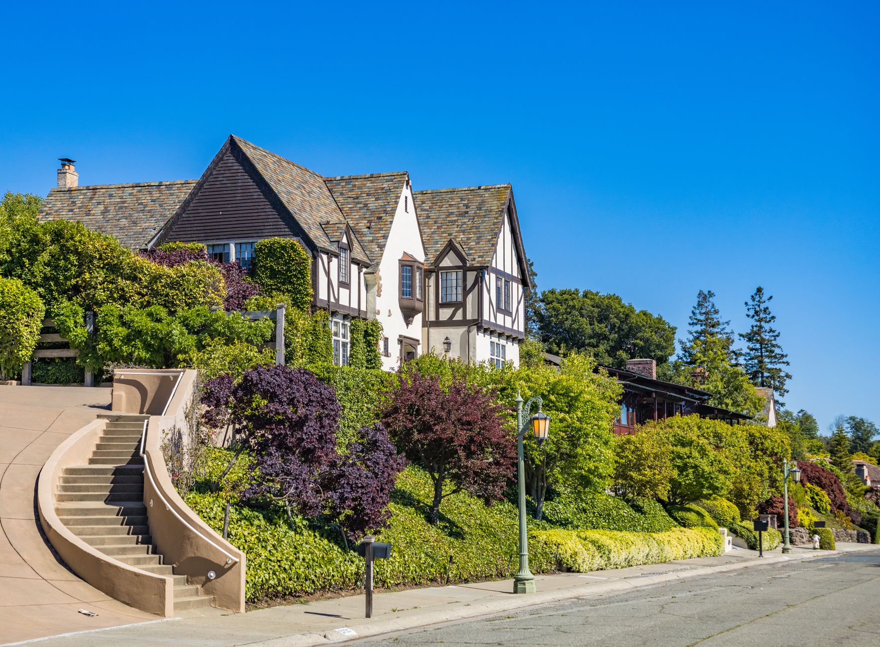 Tudor Revival house behind mature trees on a curving suburban boulevard
A slow 12-mile circuit through a suburb planned in 1913, with eight stops that trace a century of American house-building in about three hours.
The premise, and the rules of driving it
Upper Arlington was laid out in 1913 by brothers King and Ben Thompson, who bought farmland northwest of Columbus and marketed it as the Country Club District, borrowing the name and the philosophy from J. C. Nichols's development in Kansas City. Curving streets, boulevard medians, deed restrictions, no through-traffic grid. In 1916 part of the land was requisitioned as Camp Willis for National Guard mobilisation; the village incorporated in 1918. What you are driving is a legible timeline: the further north you go, the later the houses, until the 1913 English cottage vocabulary turns into 1960s brick ranch.
Three rules. Go on a weekday between 10am and 3pm, when school traffic is gone and the light rakes across the front elevations. Drive at 20-25mph — these are residential streets with children, and the posted limits are enforced. And do not get out of the car in front of anybody's house. Every property on this route is a private home; the public buildings and parks are where you park, stretch and photograph. Total distance is about 12 miles, total time three hours with stops, and it is free apart from lunch.
Stop 1: the Mallway, the village high street of 1920
Start on Arlington Avenue at the Mallway, a short Tudor-fronted commercial terrace with half-timbering, steep gables and leaded glass, built in the 1920s as the shopping heart of the new village. Park in the small lots behind it or on the street and walk both sides in ten minutes. What matters here is scale: two storeys, shopfronts at pavement level, apartments above, a green square opposite. This is a pre-car high street built for a community that was already thoroughly car-dependent, which is the central contradiction of every planned suburb of the period.
Coffee and a pastry here set you up for the drive, and the Mallway's restaurants are the closest thing Upper Arlington has to an evening district. From here, run south on Arlington Avenue to Miller Park, where the small library branch and the surrounding blocks show the earliest plats: modest English cottage and Colonial Revival houses on lots of a quarter-acre or less, built 1915-1925, many with original slate roofs and casement windows. Notice how few garages face the street. Service lanes and rear garages were part of the original design rulebook.
Stops 2 and 3: Cambridge Boulevard and the ravine streets
Cambridge Boulevard is the showpiece and the reason architecture people come here at all. Drive it slowly from north to south: a planted median, mature oaks meeting overhead, and a parade of 1920s Tudor Revival, Georgian Revival, Colonial Revival and the occasional Spanish Colonial, most of them by Columbus architects working for wealthy clients who were fleeing the smoke of the city centre. The consistency is the point. Deed restrictions dictated setbacks, materials and minimum construction cost, which is why the street reads as a single composition rather than a collection of individual egos.
Then turn onto Fairfax Drive, Roxbury Road and Kenilworth Court, where the plats meet the ravines running down to the Scioto. Here the houses step down wooded slopes, driveways drop steeply, and the planting is dense enough that you glimpse rather than see. These are the lots the Thompsons priced highest, and a century of tree growth has proved them right. The whole of this early district is listed on the National Register of Historic Places; there is no visitor centre and no plaques on every corner, so the drive is the interpretation.
Stop 4: Northam Park and the civic core on Tremont Road
Northam Park, on Tremont Road, is where the suburb keeps its public life: tennis courts, ball diamonds, a pool, broad lawns, and the main branch of the Upper Arlington Public Library at 2800 Tremont Road. Park here — there is plenty of it, and it is free — and walk the perimeter for twenty minutes. On the first Monday of September the park hosts the Upper Arlington Labor Day Arts Festival, a juried outdoor art fair that has run for decades and pulls tens of thousands of people; if your visit coincides, do the drive on a different day, because parking within a mile of here disappears.
A mile north on Tremont sits the Municipal Services Center at 3600 Tremont Road, and near Ridgeview Road you pass Upper Arlington High School, rebuilt and reopened in 2021 in a design that deliberately fronts the street rather than hiding behind a car park. The civic buildings are the honest counterweight to the boulevards: they show what a wealthy suburb chooses to spend money on collectively. Stop, look, and note how much of the school's budget clearly went on daylight.
Stops 5 and 6: the postwar north, Barrington to Ridgeview
Cross Fishinger Road and the century flips. From the late 1940s through the 1960s, Upper Arlington filled in northwards with brick ranches, split-levels and the occasional genuinely good mid-century modern house with a low-pitched roof, clerestory windows and a carport. Drive Ridgeview Road, Barrington Road and the streets around Wickliffe and Andover: wider lots, shallower setbacks, attached garages facing forward, and front doors that have stopped pretending to be English. This is the housing that made the school district famous and the population quadruple within a generation.
The interesting comparison is materials. The 1920s houses use stone, slate, stucco and leaded glass; the 1950s ones use pale brick, aluminium windows and asphalt shingle, and they have aged less romantically but often live better. Several have been scraped and replaced with much larger new-builds — the teardown wave is visible on almost every northern street and is the live planning argument in the city. Pull into Fancyburg Park at Fishinger and Reed to walk a paved half-mile loop and see the 1960s subdivision from the inside of its own green space.
Stops 7 and 8: Golf View Heights, Riverside Drive and the quarry edge
Head southwest to Golf View Heights, the pocket beside Scioto Country Club. The course opened in 1916 to a Donald Ross design and hosted the 1926 US Open, won by Bobby Jones; it is private, so admire the setting from the public streets and do not attempt the drive. The houses here face fairway greenery and range from 1920s originals to substantial 1990s replacements. From there drop to Riverside Drive and run north along Griggs Reservoir, where the road hugs a four-mile impoundment of the Scioto and the pull-offs give you the only broad water views in the city.
Finish southeast in Marble Cliff and Grandview Heights. Marble Cliff takes its name from the limestone quarries cut into the river bluff, the stone that built a great deal of nineteenth-century Columbus; Grandview Avenue's three-block commercial strip is where you should eat at the end of the loop. Sleep afterwards in the Grandview Yard hotels a few minutes away, typically $150-220 at weekends, or back in the Lane Avenue corridor at $115-165 midweek. Grandview wins if you want to walk to dinner and skip the car for the rest of the evening.
When to drive it, and what to skip
Late April to mid-May is the best window: the dogwoods and redbuds are out, and the tree canopy has not yet closed over the facades. Mid-October is the second-best, with the boulevards in full colour for roughly two weeks. January is honest but grim, and July hides half the architecture behind leaves. Avoid the first Monday of September for the arts festival, avoid the seven or so Ohio State home football Saturdays when SR-315 and Lane Avenue seize up, and avoid the 8-9am and 3-4pm school runs entirely.
Skip the interior of any historic house — there is no house museum on this route and no scheduled home tour you can rely on year-round, though local historical groups run occasional events that are worth checking with the Upper Arlington Historical Society. Skip trying to add Ohio State's campus on the same afternoon; it is architecturally rich but needs its own three hours and a different parking strategy. And skip photographing from a stopped car in a driveway. Use the parks, the library lot and the Mallway, all of which are free and all of which give you a legal place to stand.
Before you book
What people ask before booking Upper Arlington.
There is no single official driving map issued as a permanent visitor product, but the Upper Arlington Historical Society and the public library on Tremont Road hold local history material, and the early district's National Register listing is documented publicly. Ask at the library desk on arrival for anything current.
Walk the southern half. From the Mallway you can cover Miller Park, Cambridge Boulevard, the ravine streets and Northam Park in about four miles on continuous pavements. The northern postwar section is too spread out to walk pleasantly and is better sampled by car in twenty minutes.
Free lots at the Mallway, Miller Park, Northam Park, Fancyburg Park and the Tremont Road library, plus signed pull-offs along Riverside Drive at Griggs Reservoir. All are free with no time limits posted, but residential streets are for residents — do not leave a car for hours in front of a house.